![]() Prediction services for hydropower stations in Brazil
Prediction services for hydropower stations in Brazil
Hydropower is a renewable source of electricity available throughout the world as an alternative to electricity conventionally provided by thermal combustion of fossil fuels. However, the hydropower sector as it stands relies upon surface water flows of substantial volume, which makes it vulnerable to extreme drought & flood events and climate change in the long term. Accurate climate prediction is important for hydropower plant since it provides useful guidance for production plan and disaster prevention measures.
BCC signed a cooperation agreement with China Three Gorges International (CTGI) Limited in Brazil to provide climate prediction and consulting services. According to the contract, BCC is responsible for exploring the spatial-temporal characteristics of precipitation over Brazil under the background of global warming, reveal the influence and possible mechanism of the main modes of global sea surface temperature (SST) on droughts and floods, the early prediction signals of SST, and construct objective and quantitative physical empirical prediction model aims to improve the prediction accuracy of drought and flood in Brazil. Based on the relationship between leading modes of Brazil precipitation and atmospheric circulation & oceanic external forcing, BCC developed a tailored hybrid dynamical-statistical climate prediction system, which provides the monthly to seasonal prediction of target region in Brazil.

Despite the development of dynamical models, monthly to seasonal predictions of state of the art climate system models exhibits substantial systematic biases relative to observations, which hinders its usefulness unless the biases are corrected. The evaluation of multiple bias correction methods has shown that bias corrected forecast can significantly increase the reliability of climate predictions. Based on the comprehensive assessment of simulation and prediction of precipitation in Brazil and associated atmospheric & oceanic background in CMA-CPSv3, a new bias correction method was developed to reduce model bias and increase prediction skill.
Based on hindcast dataset of CMA-CPSv3, the relationship between the prediction errors of monthly and seasonal precipitation in Brazil, and key predictors (such as ENSO) are examined comprehensively. A modified quantile mapping method was used to perform model output bias correction. This method consists of calibrating the predicted empirical Probability Density Function (PDF) or Cumulative Density Function (CDF) by adjusting a number of quantiles based on the empirical observed PDF/CDF. Besides the standard unconditioned implementation of the quantile mapping bias correction, we takes into account the oceanic external forcing, i.e. ENSO phases.
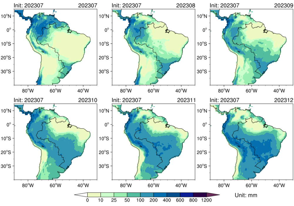
The monthly or seasonal precipitation in Brazil was classified into 8 clusters using K-means clustering methods. The K-means clustering is a widely used unsupervised clustering algorithm for atmospheric circulation regime classification. The number of clusters was firstly determined based on the distribution of within cluster sum of squares. Instead of considering the whole training dataset, the quantile mapping is fitted considering model hindcast and observed precipitation in those months for which the predicted Niño3.4 index fell into the same categories of historical runs, i.e. El Niño, Neutral and La Niña.
Compared with model direct output, the RMSD between observed and CMA-CPSv3 predicted monthly precipitation are significantly reduced. Previous studies indicate that traditional unconditioned quantile mapping method broadly preserves that temporal structure of the raw model precipitation and, as a consequence, does not improve its unskillful predictions. However, due to the incorporation of predictive information of oceanic forcing, the circulation clustering based method can modify the temporal sequence of the model raw output, providing more realistic local time series and yielding better performance of prediction. Moreover, the widely accepted source of predictability in the subseasonal to seasonal timescale, such as Madden Julian Oscillation (MJO), teleconnection patterns, soil moisture, etc., would contribute to the improvement of prediction.
![]() Han River climate prediction service
Han River climate prediction service
The Hanjiang River originates in the southern foothills of the Qinling Mountains, and empties into the Yangtze River in Wuhan City, with a length of 1577 km and a drainage area of about 159,000 km2 (Fig. 1). From 2018 to 2020, the professional climate prediction team of the Beijing Climate Center in the Hanjiang River Basin conducted research of precipitation prediction in the Hanjiang River Basin. Analyzed the climate characteristics of the Han River Basin at different time scales, and based on scientific analysis of the possible impact of weather and climate systems on precipitation in the Hanjiang River Basin, combined with advanced dynamic climate models, conducted monthly, seasonal, and Prediction services for climate trends and important monthly precipitation processes at different time scales. The climate prediction conclusions have been carefully studied and fully discussed, with standardized production of prediction products and timely services.
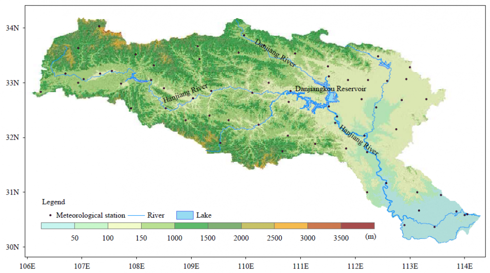
Fig.1 Geographic locations of the Danjiangkou Reservoir and meteorological observation stations over the Hanjiang River
The Beijing Climate Center provided Hanjiang River climate prediction services at different time scales, including monthly, seasonal, and annual scales. The products include: total precipitation, ten-day precipitation, percentage of precipitation anomaly, monthly precipitation process prediction products (Fig. 2), average temperature anomaly prediction in the basin, monthly temperature and precipitation trend prediction during the flood season (May to October) Monthly temperature and precipitation trend prediction during the main flood season (June to August), monthly temperature and precipitation trend prediction during the autumn flood season (September to October), annual climate prediction products, dry season climate prediction products, reservoir depletion period (May 20th to June 20th), summer autumn flood transition period (July 20th to August 20th), and end of flood storage period (September 10th to October 10th). At the same time, updated global ocean climate prediction products are provided monthly Atmospheric circulation and climate system monitoring index. The evaluation of precipitation and temperature prediction in the Hanjiang River Basin showed that the average score of precipitation was 74 points, and the average score of temperature was 79 points, achieving good prediction service results.
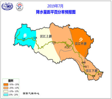

Fig.2 Prediction of the percentage of monthly precipitation anomaly in the Han River Basin (left: July 2019, right: October 2019)
In order to provide accurate and refined prediction service products in a timely manner, the professional prediction team of the Hanjiang River Basin of the Beijing Climate Center used the climate data dataset of the Han River Basin in the past 60 years to analyze the main influencing factors of precipitation at different time scales in the Hanjiang River Basin, study the precipitation prediction methods in the Han River Basin, improve the precipitation prediction model of the Hanjiang River Basin that combines dynamics and statistics, and develop and improve the climate prediction platform of the Hanjiang River Basin. At the same time, based on the actual needs of the group and the analysis results of regional climate characteristics, the refined climate prediction services in the upper reaches of the Hanjiang River was carried out. Beijing Climate Center strengthened the prediction service of upstream heavy rain processes in the Hanjiang River precipitation process prediction, and provided warning information in the prediction products to provide guarantees for the development and utilization of water resources in the Hanjiang River basin.
![]() Assessing climate change on reservoir impoundment, hydropower supply and electricity demand- A case study in the Upper Yangtze River Basin of China
Assessing climate change on reservoir impoundment, hydropower supply and electricity demand- A case study in the Upper Yangtze River Basin of China
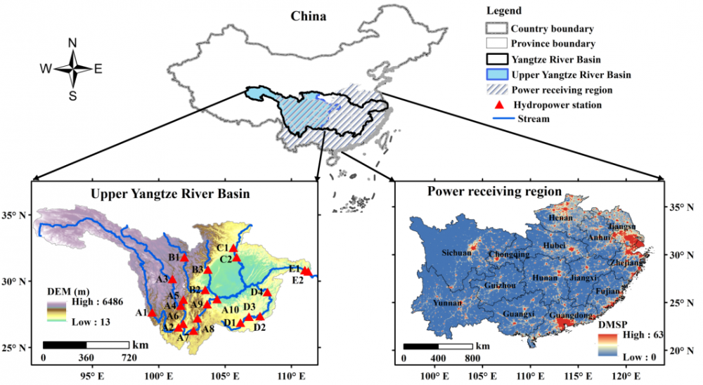
Hydropower importantly provides flexible low-carbon electricity, however, climate change will affect the hydropower system through altering hydrologic regimes while also affecting electricity demands for heating and cooling that hydropower resources serve. The methodology is accomplished by using climate projections from global climate models (GCMs) to simultaneously force (1) a physically-based hydrological model and a statistically-based hydropower model to estimate the future generating capacity of large hydropower plants and (2) an empirical electricity demand model accounting for socioeconomic and climatic factors (Fig.1).

This study assesses the effect of climate change on hydropower and electricity demand in the Upper Yangtze River Basin (UYRB) in China on the regional net electric load and greenhouse gas (GHG) emissions based on the methodology mentioned above (Fig.2).
![]() Climate services for the South-to-North Water Diversion Project
Climate services for the South-to-North Water Diversion Project
The South-to-North Water Diversion Project(SNWDP) is a fundamental project to address the uneven distribution of water resources in the north and south of China, optimize water resource allocation, and promote regionally coordinated development. It is also the largest and most widely involved strategic project in China. The plan aims to connect the four major rivers of the Yangtze River, Yellow River, Huai River, and Hai River through three water transfer routes, namely the East, Middle, and West, to form an overall layout with "four horizontal and three vertical" as the main body, in order to achieve a reasonable allocation pattern of water resources in China, with north-south allocation and east-west mutual assistance.
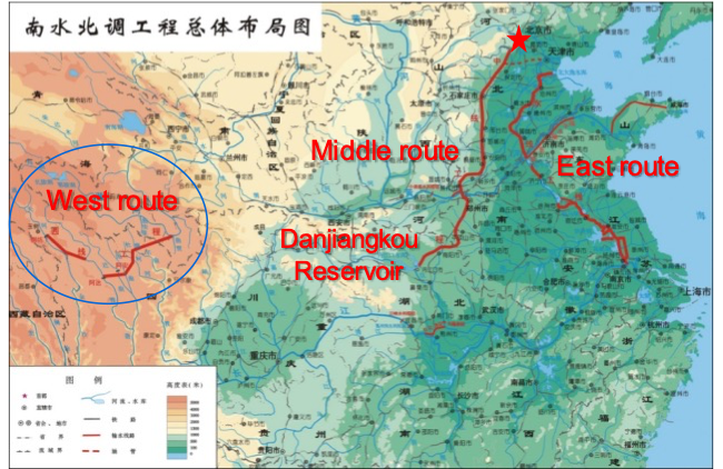
In recent years, Beijing Climate Center (BCC) has provided various forms of climate service support for the management and construction departments of SNWDP, including climate feature analysis, meteorological element monitoring and prediction, meteorological disaster risk assessment, and climate change prediction. The main service contents include:
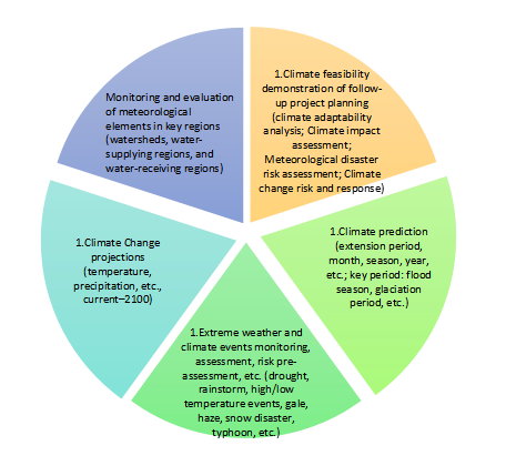
Service Case 1: Climate Change Characteristics and Suggestions in Key Regions of SNWDP
Our research has shown that in the past 65 years, the eastern route of SNWDP has experienced a trend of warming and wetting in the water transfer region and a trend of warming and drying in the receiving region. It is estimated that in the future, both the eastern route water transfer region and the receiving region will tend to become warmer and more humid, with the receiving region being significantly warmer and more humid than the water transfer region. Both the central line water transfer region and the receiving region tend to be warm and dry, with significant warming and drying in the receiving region.

Fig.3 Average precipitation in key regions of SNWDP from 1956 to 2020
Service Case 2: Climate Change Characteristics and Future Climate Change Estimation of the West Route of SNWDP
Based on the results of 24 global climate models provided by the sixth phase of the Coupled Model International Project (CMIP6), this study quantitatively evaluated the changes in precipitation and temperature in the western route of SNWDP and the receiving region under the moderate greenhouse gas emission scenario (SSP2-4.5) in the near future (2021–2040), mid-term (2041–2060), and late-term (2081–2100) of the 21st century. The results show that from 1961 to 2022, the annual precipitation in the water transfer region of the Western Route showed a significant increase trend, with a significant increase trend in autumn and winter. The frequency and intensity of extreme precipitation have increased significantly.

Friendly link
Links to GPC websites
Links to NMHSs in RA II
Copyright:© 2005 ~ 2023 Beijing Climate Centre. All rights reserved. Technical support: zhongyan
address:46 South Street, Zhongguancun, Haidian District, Beijing Zip code:100081
Today:01711/Total:34984450